Miami, FL, August 30, 2024 – The National Hurricane Center (NHC) has issued a fresh advisory today, alerting residents of two new tropical disturbances forming in the Atlantic Ocean. As hurricane season peaks, the emergence of these disturbances raises concern across coastal regions.
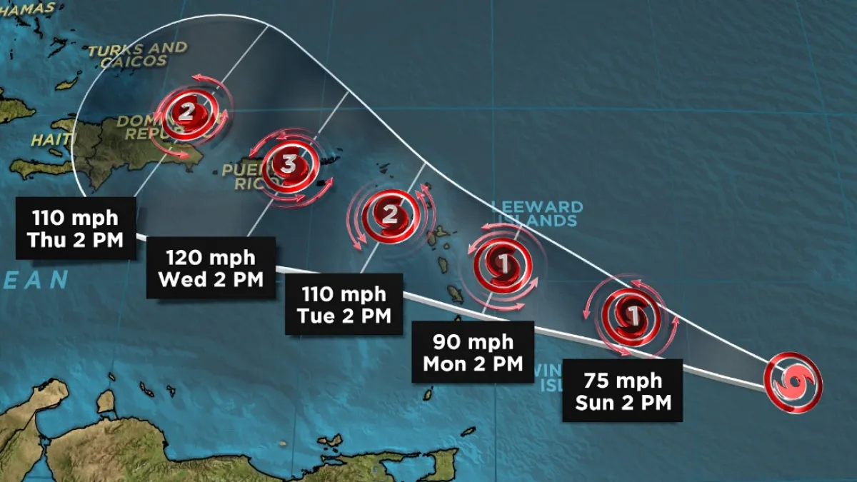
Disturbance 1: Near the Eastern Caribbean
The first tropical disturbance, located just east of the Caribbean Sea, was detected early this morning. Meteorologists have been closely monitoring this system since it first appeared as a cluster of thunderstorms earlier this week. As of now, the disturbance is moving westward at a speed of approximately 15 miles per hour.
This system has not yet developed into a tropical storm. However, forecasters note that conditions are becoming more favorable for further development. The warm waters of the Atlantic and low wind shear in the area are contributing factors. These conditions could potentially allow the system to strengthen in the coming days.
The NHC has given this disturbance a 50% chance of forming into a tropical depression or storm within the next 48 hours. Over the next seven days, the probability of development increases to 70%. If it does strengthen, it could bring heavy rainfall and gusty winds to parts of the Lesser Antilles by early next week.
Residents in the Eastern Caribbean, including the islands of Barbados, St. Lucia, and Grenada, are advised to stay informed. The NHC will continue to provide updates as the system moves closer to the region.
Disturbance 2: Farther East in the Atlantic
The second tropical disturbance is located farther east in the Atlantic, several hundred miles off the coast of West Africa. This system is still in its early stages but is already showing signs of organization. Satellite images reveal a broad area of low pressure with increasing thunderstorm activity.
This disturbance is currently moving west-northwest at around 10 miles per hour. While it is still several days away from any landmass, the NHC is watching it closely. The environment in this part of the Atlantic is also conducive to development, with warm sea surface temperatures and moderate wind shear.
Forecasters have assigned this system a 40% chance of developing into a tropical cyclone within the next 48 hours. Over the next week, the chance of development rises to 60%. If the system continues to organize, it could become a tropical depression or even a named storm by the middle of next week.
It is too early to predict the exact path of this disturbance. However, meteorologists emphasize that it is important for those in the path to stay alert. The NHC will provide more detailed forecasts as the system progresses across the Atlantic.
Heightened Vigilance for Hurricane Season
These two disturbances are a stark reminder that we are in the midst of hurricane season, which runs from June 1 to November 30. The peak of the season typically occurs in late August and September. During this period, conditions in the Atlantic are most favorable for tropical storm and hurricane development.
Over the past few weeks, the Atlantic has seen increased activity, with several storms forming in quick succession. The NHC urges all residents in hurricane-prone areas to have a plan in place. This includes having an emergency kit, knowing evacuation routes, and staying informed through reliable sources.
In addition to these new disturbances, the NHC continues to monitor the remnants of Tropical Storm Harold, which dissipated over the Gulf of Mexico last week. Although Harold no longer poses a direct threat, its remnants have contributed to increased rainfall in parts of the Southeastern United States.
Looking Ahead
As the hurricane season progresses, the NHC will remain vigilant, providing timely updates and warnings to ensure public safety. The formation of these two new disturbances serves as a reminder of the unpredictability of tropical weather. While not all disturbances develop into major storms, it only takes one to cause significant damage.
Residents in vulnerable areas should continue to monitor updates from the NHC and local authorities. Preparation and awareness are key to minimizing the impact of tropical storms and hurricanes.
In the coming days, the NHC will issue further advisories as the two disturbances continue to develop. Stay tuned to local news and weather channels for the latest information on these and other potential storms.
